Trails Offroad: Offline Maps
- 4.6
- Rating
- 50.00K
- Installs
- Free
- Price

 Analysis by App-foxy
Choosing an off-road navigation app is less about finding the prettiest map and more about deciding what kind of help you need when the pavement ends. I look for three things first: whether the trail information is useful before I leave, whether I can still work with it away from mobile coverage, and whether the app helps me judge a route rather than simply draw a line across a map. Trails Offroad: Offline Maps is built around that practical problem. It is a free Maps & Navigation app from Trails Offroad, with optional in-app purchases priced at $39.99 per item.
After spending time with it, I see it as a focused guide for people who want more context than a standard navigation app normally provides. It is not trying to be a universal replacement for every map, nor is it the obvious choice for someone who only needs turn-by-turn directions in town. Its value appears when a trip involves dirt roads, overland planning, uncertain connectivity, and the need to understand a trail before committing to it.
What I would check before choosing an off-road guide
My first decision criterion is the difference between a map and a trail guide. A conventional mapping app may show roads, tracks, terrain, and a route between two points, but that does not automatically tell me what the drive will feel like. Off-road travel raises different questions: Is this route worth planning around? Where might I need to slow down? Does the trail make sense as part of a larger day? Can I study it before I am standing at a junction with a weak signal?
You May Also Like

 Blood Strike: 2.5 Anniversary
Blood Strike’s Loadouts Turn Every Drop Into a Tactical Gamble
A close look at Blood Strike’s custom loadouts: how fast access to signature weapons reshapes its battle royale rhythm, rewards preparation, and narrows the gap between fights.

 Pandora - Music & Podcasts
Pandora’s Music Is Easy to Start, but Harder to Recover
Pandora’s strength is its low-effort path from a seed to a station. Its weak spot is how much confidence it asks you to place in connection, setup, and quiet recovery.

 8 Ball Pool
 Is Built on Rivalries, Rematches, and Routine
A close look at the rivalries, rematches, shared routines, and unanswered safety questions that turn a quick pool match into a persistent mobile community.

 Samsung Music
’s Quiet Strength Is Playing What You Already Own
Its reach comes less from spectacle than from dependable access to a personal library. That simplicity is both the app’s strongest retention engine and its ceiling.

 AccuWeather: Weather Radar
AccuWeather Review: A Quick, Clear Forecast for Everyday Decisions
For everyday plans, the best forecast is the one you can understand quickly. AccuWeather makes rain timing, radar, and local conditions easy to act on, with a few trade-offs.

 Hill Climb Racing
Why Hill Climb Racing Still Turns Crashes Into One More Run
A tiny car, a bumpy hill and one more upgrade: Hill Climb Racing keeps resurfacing because its simple chaos makes every near-miss feel personal.
More From Our News Desk
View All News


That is where the app’s purpose becomes clear. Trails Offroad is designed around offroad and overland trail guides that can be used offline. I would not judge it by the same standard as a city navigation tool. I would judge it by how well it supports preparation, route selection, and reference use when a phone connection is unreliable.
The second criterion is how much preparation I am willing to do. Offline navigation is useful only when the relevant material has been prepared before leaving coverage. That creates a small but important habit: I need to decide on my trails, review them, and make sure the information I expect to use is available before the trip starts. This is not a flaw unique to this app; it is the trade-off that comes with depending less on a live connection.
The third criterion is whether I want a specialist experience or a broad one. A general map app is often better for finding a fuel stop, checking traffic, locating a shop, or navigating the final paved section to a trailhead. A dedicated off-road guide can be better for understanding the trail itself. In my view, the most sensible approach is not to force one app to do both jobs. I would use a general navigation tool for the ordinary road journey and keep this app for the off-road planning and reference work.
The fourth question is cost. The application itself is free, which makes it easy to install and inspect without committing immediately. The optional purchases change the decision, though, because the useful question is not simply whether the download costs anything. It is whether the trail guidance available through the purchase is valuable enough for the trips I actually take. Someone who drives a few maintained gravel roads may not get the same value as a regular overlander who plans around trail networks.
How the app feels in a realistic trip
Imagine I am planning a weekend drive that starts with several hours on normal roads and ends at a remote campsite. The first evening, I would use the app as a planning tool rather than waiting until I am already moving. I would look through the available trail material, compare possible routes, and decide which one fits my vehicle, time, and comfort level. The important benefit is that the trail becomes part of the decision before I reach the turnoff.
On the morning of the trip, I would prepare the offline material while I still have a reliable connection. That step is easy to overlook, especially when the app is free to install and feels like something I can simply open whenever needed. My practical tip is to treat offline preparation like charging a power bank: do it as part of the departure checklist, not as an emergency task beside the trailhead.
Once I leave the main road, I would use the app as a reference rather than staring at the screen continuously. I prefer to stop at safe points, confirm where I am, and then continue with my attention on the track. This workflow matters because an off-road guide should support judgment, not replace it. A phone can help me understand a route, but it cannot inspect a muddy section, account for a sudden storm, or decide whether my vehicle and passengers are comfortable with the conditions.
A less obvious advantage is that offline material can reduce the mental pressure of trying to keep a connection alive. In remote areas, repeatedly waiting for a map tile or refreshing a route is distracting. Having the relevant guide ready beforehand means I can focus on the route and use the phone more deliberately. That is especially helpful when a group is traveling together and the person navigating needs to give clear instructions without stopping to troubleshoot reception.
Where Trails Offroad is strongest
The clearest strength is its specialization. The app is not presented as a general-purpose map with a few dirt roads added on. Its identity is tied to off-road and overland trail guides, so the experience is aimed at a driver who wants trail-oriented information. For me, that focus makes it more useful during the planning stage than a basic map view that only shows lines and road names.
It also makes sense for people who repeat a style of travel. If I regularly plan camping routes, explore backcountry roads, or build multi-stop overland trips, a dedicated guide can become part of my routine. I can use it to narrow down options before I spend fuel and time reaching a trail. That is a different kind of value from simply finding the fastest route between two addresses.
Another strength is the offline emphasis. It changes how I think about the app. I do not need to treat it as a live service that must constantly update while I am driving. Instead, I can prepare a route in advance and use the phone as a compact trail reference. The trade-off is that preparation becomes my responsibility, but the payoff is a calmer experience in places where connectivity is not something I can take for granted.
The app’s audience also appears broad enough for beginners and experienced travelers, although they will use it differently. A beginner may appreciate having a structured way to research a trail rather than choosing a route blindly from a standard map. An experienced driver may use it to compare alternatives, assemble a day plan, or keep a trail reference available without relying on a signal. Neither user should mistake the guide for a guarantee of current trail conditions.
That last point is important. Trail environments change. A route that looked manageable during planning can be affected by weather, maintenance, closures, fallen trees, erosion, or vehicle restrictions. I would always treat the app as one source of preparation and combine it with local signs, current conditions, and my own judgment. The app is strongest when it helps me make a better-informed decision, not when I ask it to make every decision for me.
Small habits that make it more useful
My first practical habit would be to plan an alternative before leaving. Off-road itineraries are more vulnerable to delays than ordinary road trips, and a route that looks perfect on the screen may not suit the day once weather, daylight, fuel, or group experience enters the picture. I would keep a second trail or an easier exit in mind rather than treating the first choice as fixed.
My second tip is to separate route confidence from vehicle confidence. A detailed guide can help me understand where I am going, but it does not turn a two-wheel-drive vehicle into a trail rig or make worn tires suitable for difficult ground. Before relying on a route, I would ask whether the vehicle, passengers, recovery equipment, and driving experience match the trip. That is a crucial trade-off for any off-road navigation product.
My third tip is to use the app before the trip with the whole group. If I am traveling with friends, I would discuss the planned route while there is still time to change it. This avoids a common problem in outdoor travel: one person assumes the trip is a relaxed scenic drive while another expects a demanding technical section. A guide is more valuable when it improves the group’s shared expectations.
I would also avoid using the phone as the only safety reference. Offline access helps with navigation, but I would still carry basic backup planning, keep the device charged, and know how to turn around. The app can reduce dependence on a signal; it cannot remove the risks of isolation or poor weather.
Where a different kind of app may fit better
There are clear situations where I would choose something else, or use something else alongside it. If my main need is live traffic, business search, public transit, or ordinary address-to-address navigation, a mainstream map service is likely more convenient. Those tools are designed for everyday movement through populated areas, and I would not want a specialist trail guide to handle every part of a normal commute.
I would also look for a different solution if my priority were highly flexible mapping rather than guided trail discovery. Some users prefer building their own tracks, importing routes, recording every drive, or working with a particular map layer. If that is the center of my workflow, I would compare the app carefully with a dedicated track-recording or route-planning tool rather than assuming an off-road guide will cover every advanced mapping preference.
Another alternative may suit people who travel only occasionally and already have a trusted paper map, local knowledge, or a well-established navigation setup. For a single easy gravel-road outing, paying for optional content may not feel worthwhile. The free entry point makes testing less intimidating, but value still depends on how often I will use the trail guidance and how much planning support I want.
There is also a difference between exploring and navigating. An app centered on trail guides can help me decide where to go, but a driver who wants a continuous spoken navigation experience may prefer a tool built specifically around turn-by-turn directions. I would not choose this app solely because I expect it to behave like a car navigation system on every part of a remote journey.
In short, the alternatives are not necessarily competitors in every situation. A general map is better for the approach roads. A flexible mapping tool may be better for creating and recording custom tracks. Local information may be better for very recent closures or conditions. Trails Offroad makes the most sense when the missing piece is dedicated trail context and offline preparation.
The real cost of switching to it
The financial entry point is straightforward: the app is free, while optional in-app purchases are listed at $39.99 per item. The more meaningful cost is the change in routine. I would need to spend time learning how to browse the trail material, deciding what I need for a trip, and preparing it before leaving coverage. That is a small investment for a regular overlander, but it may feel unnecessary to someone who takes one casual off-road drive every year.
There is also a switching cost in expectations. People accustomed to live maps may assume that every route will behave like a continuously updated road journey. With an offline-focused trail workflow, I have to think ahead and accept that the phone is a prepared reference. Once I adopt that mindset, the experience feels more dependable in remote areas, but the preparation cannot be skipped.
On the device side, the app supports Android 7.0 and later, which keeps it available to people using older compatible Android phones. It is rated for Everyone, so the age classification is not a barrier for ordinary family use. The current version is 4.1.1, and the app was released on November 23, 2021. I would still make sure my phone has enough battery and storage for the trip, because offline navigation is only useful if the device remains usable when I need it.
The app has an average rating of 4.6 from over 300 ratings, with more than 150 written reviews, and it has passed 50 thousand installs. Those figures suggest a real user base and generally favorable reception, but I would not use them as a substitute for matching the app to my own travel style. A high average cannot tell me whether the available trail coverage suits my region or whether the purchase model fits my budget.
That regional question is one of the first things I would investigate inside the app. Before paying for optional content, I would check whether the trails I actually want to drive are represented and whether the guidance matches the kind of trip I plan. This is a better test than browsing popular routes that are far from home. The right content in the wrong location is still poor value.
My recommendation after weighing the trade-offs
I recommend Trails Offroad: Offline Maps to drivers who plan off-road or overland trips and want more than a generic line on a map. Its strongest case is a traveler who values preparation, expects patchy connectivity, and wants trail-focused guidance available before and during a remote drive. The free download makes it reasonable to explore the experience first, while the optional purchases require a more deliberate decision based on actual route needs.
I would especially recommend it to someone who is moving from casual dirt-road driving toward more organized trail trips. It can encourage better planning: review the route, prepare offline access, discuss the plan with passengers, and keep an alternative ready. Those habits are more important than any single map screen, and the app fits naturally into that process.
I would not make it my only navigation tool for a mixed trip. For the paved journey, live traffic, services, and ordinary destinations, a general mapping app remains more practical. I would also skip it if I rarely leave maintained roads, dislike preparing routes in advance, or mainly want to record custom tracks rather than follow trail guides.
My final view is that the app earns its place by being specific. It does not need to replace every navigation product to be useful. When I am planning an overland route and want offline trail information ready before reception disappears, that specialization is exactly what I want. The best reason to choose it is not that it promises effortless exploration, but that it supports better decisions before the difficult part of the drive begins.
FAQs for Trails Offroad: Offline Maps
01What is Trails Offroad: Offline Maps?
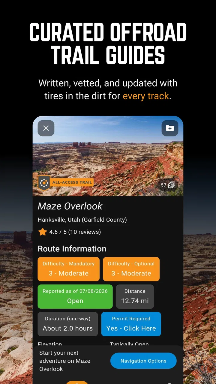
Trails Offroad: Offline Maps is a navigation and trail-planning app designed for off-road drivers, overlanders, and outdoor explorers. It provides information about selected trails, including routes, difficulty levels, points of interest, photos, and practical notes. The app is intended to help users prepare for trips and navigate areas where mobile coverage may be limited.
02Can Trails Offroad: Offline Maps be used without an internet connection?
Yes, offline access is one of the app’s main advantages, although users should prepare before leaving home. Download the required trail information and map data while connected to Wi-Fi or mobile data, then confirm that the content is available offline. GPS positioning can generally continue without cellular service, but live updates, online searches, and newly loaded information may require an internet connection.
03Does the app provide turn-by-turn navigation?
Trails Offroad: Offline Maps focuses primarily on trail discovery, route information, and off-road navigation rather than functioning exactly like a conventional city-navigation app. Depending on the selected trail and available features, it may provide route guidance, waypoints, and detailed directions. Users should read the trail description carefully and avoid assuming that every route offers continuous, voice-guided turn-by-turn navigation.
04What kind of trails and vehicle information are included?
The app is particularly useful for discovering four-wheel-drive and overlanding routes, with trail pages commonly including difficulty ratings, estimated distance, elevation changes, obstacles, scenery, and recommended vehicle capabilities. Conditions can change because of weather, maintenance, closures, or seasonal restrictions, so the information should be treated as planning guidance. Always verify local regulations and current access conditions before starting a trip.
05Is Trails Offroad: Offline Maps suitable for beginners?
It can be helpful for beginners because trail descriptions, difficulty ratings, photos, and preparation notes make it easier to understand what a route may involve. However, the app cannot replace practical off-road skills, recovery equipment, weather awareness, or responsible decision-making. New drivers should begin with easier trails, travel with suitable equipment and companions, and turn around whenever conditions exceed their experience or vehicle’s capabilities.
Pros
- Detailed trail descriptions with difficulty
- length
- and elevation data.
- Offline map access is useful in areas with weak or no mobile signal.
- Helpful route guidance supports planning before starting a hike.
- Trail photos and user insights make route selection easier.
- Regular content updates can add new trails and improve information.
Cons
- Many useful trails and features require a paid subscription.
- Coverage varies by region
- especially outside popular hiking destinations.
- Downloading maps beforehand uses considerable device storage.
- Battery consumption may increase during long GPS-guided hikes.
- Some trail information can become outdated after weather or route changes.

Trails Offroad: Offline Maps
Gallery